
When we talk about geography, we could focus on a lot of things, but a huge element of the national curriculum at Primary school level is about understanding the physical and human geography around us. There are physical processes to develop an understanding of and the impact these processes have, such as rock formation, the impact of plate tectonics, and the effect of erosion. There is also the necessity to study the impact that we, as humans, have had on our world, looking not just at buildings and structures but also at infrastructure such as road construction and the development of other features for trade and transport. Ensuring that we encourage the art of comparison is crucial to developing children with a secure knowledge of geography. Now, I’m not just talking about how one geographical feature may be bigger than another (although lower down in Primary schools, these simple comparisons are an important starting point). We must develop a clear and modelled approach to developing these comparisons as the children learn.
Physical features vs human features
Why then, did I start this blog by talking about physical and human features. Well, I don’t think that children can develop a proper understanding of their locality if they don’t consider the similarities and differences between the human and physical features that are around them. Now, some are obvious. The difference between a hill or mountain and a house is a silly example, but when discussing younger children, we want to make those obvious comparisons. However, the art is in developing that skill of comparison with more similar features as the children gain confidence. My go-to examples are things like rivers and canals.


To children, at first glance, they just look like channels of water. Children are often quick to judge geographical features that are similar by their similarities. I don’t blame them for this. If you are walking by a river or a canal as a child, you might see similar animals, the water seems to travel in a line from one place to another, but it’s developing the children’s ability to notice the differences (which some are subtle and some are more obvious when you begin actually to look for them). Lakes and reservoirs are another great example to explore.


Now, what we are trying to do is support the children in developing their understanding of how these features are different. What makes rivers and lakes physical? Well, rivers start as small collections of rainfall at the top of a hill or mountain, forming tributaries, streams and then rivers. They sometimes flow into larger bodies of water that are too wide to be called rivers – these are lakes. Rivers always flow out towards the sea. There are other effects that rivers can have on the land, such as forming natural meanders or eroding and cutting through hills to create amazing ‘v-shaped’ valleys. Why is this different from a canal? We need to develop children’s understanding that canals are purpose-built. Within Britain, a canal system was developed to support the transport of goods and travel around the country. Then, it’s about getting children to look at the fundamental differences. Canals often look still whilst rivers continuously flow with a visible current. Canal boats are also an obvious sign, alongside the built-in locks supporting travel around the network. The same needs to be considered when looking at lakes and reservoirs, and when looking at images, we need to encourage the children to look for evidence of human work, such as the stones or bricks laid to hold water within a reservoir.
There is a further need here: giving children experiences of these physical and human features. You know your local area, but if you have a river and a canal that you can physically visit, then doing fieldwork here is important to really support children’s knowledge of these features.
Taking comparisons further
It’s also essential to compare human features with each other, and the same applies to physical features. If we want to develop children’s abilities to ask more perceptive questions and consider their own enquiries, then we need to model this. Let’s start by considering human features. I think two examples can be really powerful and encourage children to develop their thinking skills, especially when discussing observation. The first is roads. The children will have seen several types of road, but have they experienced all the different types? Quiet streets, main roads, cul-de-sacs, motorways, country lanes; the list goes on and on. Encouraging the children to consider why we have different types of road, where they have been laid and why they have been laid there is important in developing geographical understanding. What is the impact that these different road types have on their locality? Why do we need motorways?
We can go down the same route if we consider building development, too. There are many different types of buildings, all with different uses. Children can survey the different uses of buildings in their local area. They can look at where building use has changed. They should be encouraged to consider the ‘why’ of different buildings and their uses and impact on the local area. Making comparisons in this way supports children in their geographical understanding of their locality, and they begin to apply this to the wider world.
Of course, the same approach can be taken with physical geography. Looking at something like plate tectonics, a range of differences can be explored. Firstly, the plate boundaries react in different ways. This has different effects, whether regular minor tremors or infrequent but more significant earthquakes or volcanoes. It’s also important to consider the short-term and long-term impact of plate tectonics, such as the formation of mountains due to specific plate boundaries. There is so much geography to explore here, and an awful lot of it can be explored successfully by developing the art of effective comparison and analysing the impact of these geographical features.

Developing understanding beyond their locality
What’s also great about developing the ability to compare things effectively is that it opens up the world of geography to children. When we look at the geography of other parts of the world, we need children to have a solid knowledge base about their own world to make further connections with the wider world. This applies to everything, but going back to some of my previous examples, if the children have a strong understanding of what a canal is, they can then look at canals in other parts of the world, such as the Suez Canal in Africa, the Panama Canal in Central America or the Corinth Canal in Greece. They can compare what’s similar about them, but they can also look at the different levels of physical geography that the construction of these canals would have had to approach. The scale of these canals is also completely different.
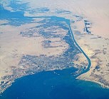


Suez Canal Panama Canal Corinth Canal
Putting things into perspective is so important in geography. If we don’t give children that solid grounding in the difference between physical and human features, how can we expect them to understand those bigger elements of geography across the world? We must give children as much first-hand experience as possible within their locality. By this, I mean actual fieldwork in order to make those comparisons within the world that they know so that they can apply this to further contexts throughout their learning and their lives.
Making observations
If we make these observations during fieldwork, we need to ensure that we collect some data. If we are making comparisons by looking, then field sketching is a great way to do this. Start simple, identify key reference points, and then encourage children to add the details of the feature you are looking at so that it can be compared effectively to other field sketches. Using surveys can also be a great way to make these comparisons. Returning to buildings, survey how many buildings in a street are houses and how many are used for something else. This can then lead to further discussions. Making comparisons is such a powerful tool.
Using maps can also be a fantastic tool for developing the art of comparison. When children have developed a solid enough basis, looking at two different maps alongside each other can show you how land use has changed over time. Here’s an example from NLS Maps (a free online mapping tool):

So there it is. The art of comparison. It’s so important to get this aspect of geography right to develop children’s ability to know more and remember more about the geographical features they study within your school’s curriculum.
Related Resources


Browse our range of Geography-related products here.
CONNECT WITH US
Twitter/X | focuseducation1
Bluesky | focuseducation
Facebook | focuseducation1
Instagram | focuseducation1
Linked In | Focus Education
Subscribe to our YouTube Channel